- Joined
- Jul 4, 2008
- Messages
- 2,499
- Points
- 113
I just got back from a fairly long trip into B.C. 's desert, the Okanagan valley. Lots of wine tours, walking and sightseeing. One evening last week I left my Wife and Sister-in-law to have some beach time. I grabbed my survey meter and headed up to an area I monitored last year for anomalous radioactivity but failed to find anything. ( I left disappointed and empty handed)
Using a map from courtesy of Minfile ( BC Govt online mining resource) hand drawn in 1977 I followed the banding in the rocks and got to an area that was now open due to a new roadway connecting to a yet constructed housing development. I had my survey meter on 1x setting and the survey meter was connected to my digital meter on my dashboard of Jeep grand Cherokee. As I drove up the hill my background remained ~70CPM, with minor fluctuations driving near open rubble piles. As my car rolled past a pile of pinkish rock, I noticed the counts start to climb rapidly (4x - 7x background) - up to 360-500CPM. This have me a an idea as to where this sporadic radioactivity was coming from. I pulled open my phone and read the notes filed - and the literature made a specific mention of pink grit being a host of some "Thorium" mineralization, although there was no specific identified mineral in the location, ie random radioactivity from host rock... Not really useful info..
The rubble pile turned out to be only very slightly elevated....Then I made a decision to walk towards the area where the rock pile had come from which was blocked to road traffic. Immediately my counter started picking sporadic radiation again. I walked a little bit further and I then came to the side of a rock face that had been exposed by drilling with large orangey brown spots, some being oddly rectangular ringed with purple ( looking not too unlike radiation damage or a burn spot). Several of these spots being at least 10cm across sent my GM detector far off scale on 1000x. My GM counters exposure alarm instantly sounded. - smaller spots gave count readings 7-10KCPM range and only moderately larger spots were in the 60-100KCPM range.
I raced back to the car and grabbed a geologists pick and hammer and was able to knock off a sizable slab of this new undocumented Radioactive mineral.
Pictures posted below.
I have sent off pictures to Mindat and will be sending pics to UBC for analysis this week. They will also likely want a sample from me as well.
As of this morning I was able to get a decent Gamma spectral analysis done confirming U mineralization. Most likely it is a form of Gummite ( one of a few secondary U minerals mashed together)
If confirmed by UBC, it will be the first identified uranium mineral in the area ever recorded.
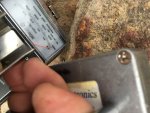
Meter pegged on this spot -- patch was 10cm across
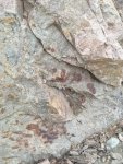
All those purple marks are mats of conc. uranium mineralization note the orange brown staining and pink host rock.
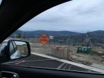
No berrier will stand in my way... our source of sporadic radioactivity lay just beyond this berrier.
A pink git granite/feldspar rock face

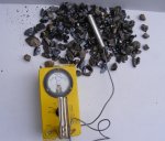
My best sample -- 12,000CPM on a pancake probe and 50,000CPM on a NaI/Tl Scintillator.
Using a map from courtesy of Minfile ( BC Govt online mining resource) hand drawn in 1977 I followed the banding in the rocks and got to an area that was now open due to a new roadway connecting to a yet constructed housing development. I had my survey meter on 1x setting and the survey meter was connected to my digital meter on my dashboard of Jeep grand Cherokee. As I drove up the hill my background remained ~70CPM, with minor fluctuations driving near open rubble piles. As my car rolled past a pile of pinkish rock, I noticed the counts start to climb rapidly (4x - 7x background) - up to 360-500CPM. This have me a an idea as to where this sporadic radioactivity was coming from. I pulled open my phone and read the notes filed - and the literature made a specific mention of pink grit being a host of some "Thorium" mineralization, although there was no specific identified mineral in the location, ie random radioactivity from host rock... Not really useful info..
The rubble pile turned out to be only very slightly elevated....Then I made a decision to walk towards the area where the rock pile had come from which was blocked to road traffic. Immediately my counter started picking sporadic radiation again. I walked a little bit further and I then came to the side of a rock face that had been exposed by drilling with large orangey brown spots, some being oddly rectangular ringed with purple ( looking not too unlike radiation damage or a burn spot). Several of these spots being at least 10cm across sent my GM detector far off scale on 1000x. My GM counters exposure alarm instantly sounded. - smaller spots gave count readings 7-10KCPM range and only moderately larger spots were in the 60-100KCPM range.
I raced back to the car and grabbed a geologists pick and hammer and was able to knock off a sizable slab of this new undocumented Radioactive mineral.
Pictures posted below.
I have sent off pictures to Mindat and will be sending pics to UBC for analysis this week. They will also likely want a sample from me as well.
As of this morning I was able to get a decent Gamma spectral analysis done confirming U mineralization. Most likely it is a form of Gummite ( one of a few secondary U minerals mashed together)
If confirmed by UBC, it will be the first identified uranium mineral in the area ever recorded.

Meter pegged on this spot -- patch was 10cm across

All those purple marks are mats of conc. uranium mineralization note the orange brown staining and pink host rock.

No berrier will stand in my way... our source of sporadic radioactivity lay just beyond this berrier.
A pink git granite/feldspar rock face

My best sample -- 12,000CPM on a pancake probe and 50,000CPM on a NaI/Tl Scintillator.


