Welcome to Laser Pointer Forums - discuss green laser pointers, blue laser pointers, and all types of lasers

Buy Site Supporter Role (remove some ads) | LPF Donations

Links below open in new window

ArcticMyst Security by Avery | Browser Hide by Avery

850nM Well Water Level Measurement?

tma

New member
Joined
Aug 21, 2019
Messages
4
Points
3
Greetings,

I would like to monitor the ground-to-water-surface-level vertical separation distance in a well using a TOF 850nM laser range sensor. The water is visibly very clear and has some mineral content. The beam would be perpendicular to the plane of the water surface. I have three questions:

1) I wonder if the clear water will reflect the sensor beam sufficiently to permit successful measurement of the water level when the distance approaches the the maximum range of the sensor?

2) I wonder what percentage of the incident beam would be reflected by the visibly clear water?

3) I noticed infrared range sensors with wavelengths that vary from 600-900nM. I wonder what the best wavelength would be for this application?

Thanks in advance for any helpful comments and/or suggestions.

tma


I'm sure more members would be inclined to help you
if you introduced yourself to the Forum community
in the Welcome section.

Jerry
 
I am a professional contractor and have installed many wells.
Without getting into AOI or absorption per wavelength, just try it. Then compare it to the 100% reliable string with a weight and float on it. For a deep well, I would wonder about alignment and bounces off the well casing.
 
Greetings Diachi,

Thank you for your response!

The well I am interested in monitoring is roughly 10M deep with a 1.2M diameter concrete crib. I find I can measure it accurately with a laser measuring tool that operates around 650nM. But if I use that same measuring tool to measure crystal clear water in a pail it the beam penetrates the water and measures the distance to the bottom of the pail. I imagine there may be some film on the surface of the well water that reflects the beam better than the clear water in the pail. I have read that with aircraft surveying it is possible to map either a lake bottom or the surface of the lake by changing the laser wavelength which leads me to believe there may be an optimum wavelength to use for measuring water surface level. I am hoping to find someone here that can clarify this.

Thanks Again,
TMA
 
At 0 degree angle of incidence, almost all light is transmitted into water (not reflected). Also, generally, as wavelength increases so does absorption. This means that shining a laser straight into water will not reflect much. Further, the reflection becomes weaker as wavelength goes toward IR spectrum.
Most commercial well monitors are sonic or ultrasonic based. Hopefully some of the real physics guys from this website will chime in.
 
Greetings Tony,

Many thanks for the info - it got me thinking of the well bottom echo round trip attenuation within the currently 20 ft column of water!

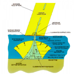
I ran across a blog on Bathymetric Lidar (https://geozoneblog.wordpress.com/2013/09/25/bathy-lidar-harder-than-it-looks/) which describes the use of airborne lasers for charting the depths of lakes. I found the attached illustration which shows a reduced reflection from the surface. I am now theorizing that a possible reason my laser measuring tool works accurately for the well water level detection but not for a pail of clear water is that the reflection from the bottom of well, which is 20 feet below the present water level, is totally attenuated by the 40 ft round trip path through the water. The measuring tool which I imagine measures the time of flight for the strongest echo return is probably responding to the weak reflection from the water surface as the reflection from the bottom would be most likely lost within the 40 ft water return path.

TMA
 

Attachments

  • bathy_lidar_physics_2.png
    bathy_lidar_physics_2.png
    197.5 KB · Views: 4


Back
Top